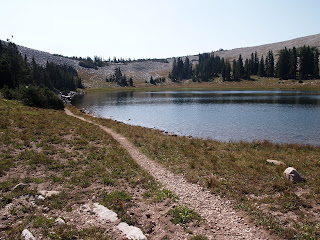
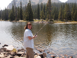
This was a spur of the moment walk. .
We walked up to Cecret Lake in Albion Basin.
Behind the Lake we found a creepy cave:
We climbed around on some rocks by the lake.
Perfect blue sky:
All it takes to find a friend is a pocket full of peanuts.
We may be going up Mount Baldy next Saturday. We are cramming in some hikes before the snow flies.
Saturday, August 25, 2012
Saturday, August 18, 2012
Lofty Lake Loop And Mt. Goats
We were in the car at 6:00 A.M. and on the trail at about 8:00 A.M.
This is the Lofty Lake Loop.
It's along the Mirror Lake Highway and begins at the Pass Lake Trail head.
Reids Meadow:
On the left is the backside of Mt. Baldy:
Morning in a meadow:
The trail climbed a rocky slope to the north. It brought us to Kamas Lake.
There was a family of Mountain Goats there!:
Joe:
After a rest we headed on. We crossed a small man made dam at the northwest end of the lake.
From there we made another steep climb to a high mountain meadow.
We went up a rocky slope to a crest above the meadow (elevation of 10,700 feet). We could see Teal Lake, Cutthroat Lake (behind me here) and Jewel Lake to the North.
Joe liked looking at the views while sitting on a big rock:
We reached a plateau.
This is Lofty Lake. 10,840 feet.
We had lunch here:
The trail reached 10,920 feet before we started down the other side.
Below is Scout lake, which serves the Scouts at Camp Steiner:
Our trail:
Scout Lake in center.
Pass Lake way off to the right of the picture:
Scout Lake:
Smaller Lake, just south of Scout Lake:
We worked our way down the mountain until we reached the parking lot.
Then we drove very short distance (practically across from our trail head).
We parked and did a little fishing.
We played here for about an hour:
Provo River Falls:
We stopped at the Kimball Junction Mcdonalds for a small hamburger and an Ice-cream cone.
We put 12 hours to good use today.
Monday, August 13, 2012
Doughnut Falls
We took an easy walk to Doughnut Falls after work this evening.
It's so much nicer to find a local trail than to walk around the boring neighborhood.
We burned just enough calories to go eat a chocolate dipped ice-cream cone. We often break even that way.
It's so much nicer to find a local trail than to walk around the boring neighborhood.
We burned just enough calories to go eat a chocolate dipped ice-cream cone. We often break even that way.
Friday, August 10, 2012
Mt. Aire
Joe was 'out of town'.
I went on a very rare solo hike.
The trail starts in Millcreek Canyon.
I was on the trail at about 8:00 a.m.
Along a creek:
The saddle.
Looking North into Parleys:
Mt Aire to the East:
Looking back the way I came.
I went most of the way up Mt. Aire.
Looking down into Mill Creek:
You can see the trail down below.
It's that tiny line down there to the right:
It doesn't show well in the picture, but I could see some of Salt Lake valley:
Mill Creek has very steep trails that almost never level out.
It's fun though.
Monday, August 6, 2012
Family at Mom and Dads
My Brother-In-Law was in town (from Calif.).
Dad, Richard (B in Law), Brian (brother):
Brad and his kids:
Mom:
It was fun!!
Saturday, August 4, 2012
Mill Creek To Park City Overlook
This morning I got on a trail in Mill Creek that went up to the Park City Overlook.
I did this while Joe was out on the Salt Flats watching rocket launches.
So while he was getting his retinas burned out , I headed for greenery and shade.
This trail was 5.2 miles round-trip to the ridge line saddle.
I followed a section of the Old Red Pine Road Trail:
Some of the lower trail:
Upper meadow:
I made it to the Park City Overlook!
If you're crazy enough, you can walk from Mill Creek to Park City:
The log where I sat and had lunch:
The hike took me about 5 hours because I like to look around and take pictures.
As a general rule I never hike alone (but I will if I have too!)
So, hooray for me! I did it and I had a nice day.
Subscribe to:
Comments (Atom)


